Canoeing West Chickamauga Creek – Nature Bathing
Canoeing, kayaking, floating, swimming — I was born to be on the water. Lucky us: We LIVE on West Chickamauga Creek, the boundary between Walker County and Catoosa County in Northwest Georgia. Our 6-acre Spirit Tree Farms property is across the creek from the #ChickamaugaNationalMilitaryPark (actually in the Southeast corner of the park, where there’s a “bite” out of it.)
On the last Friday in July, 2022, (thanks to my company for giving me a day off: #BeF5 #AForceFor #NatureObservation and #NatureRenewal,) my wife and I took a S L O W canoe trip on the West Chickamauga Creek from Lee and Gordon’s Mill in Chickamauga, Walker County, NW Georgia, downstream (winding North) for 3.5 hours (about 4 miles) to our property across from the #Chickamauga National Military Park (about a mile upstream from the Alexander Bridge).
In our #MadRiverCanoes, we saw numerous birds, animals, and surprisingly few bugs bothered us. The day was warm, but not too muggy, with a nice breeze coming off the water. In the video, the background sounds are provided by the #NativeAmerican fishing weir rapids, bugs, frogs, etc. for #NegativeIon health benefit (#forestbathing + #CreekBathing). The photography is from CreationGirl.com. (You can read her impressions of the trip at “Syncing Up With Nature / CreationGirl.com).
I’m making this video and blog as a practical way to introduce people around Chattanooga and Northwest Georgia to the joys of a VERY EASY yet VERY REMOTE float on the West Chickamauga Creek. The float, from Lee and Gordon’s Mill in Chickamauga, south to our property (and then beyond to the Reed’s Bridge or O’Charley’s takeout points) borders the Chickamauga National Military Park, created in the 1890s. Much of the left side of the creek bank is the same as it was just after the Civil War.
Lessons Learned Canoeing West Chickamauga Creek
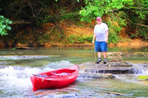
The biggest obstruction (besides some trees that fall in the creek on occassion, but which are usually cut apart by volunteers or swept downstream by the current) is a small waterfall (rapids) about 3-4 feet high at low water, about 2.5 hours south of the launch point. As you can see in the video, you can either walk your boat down, OR run it on the right or right-of-center side of the falls.
Warning! The West Chickamauga Creek Floods!
Wait a few days for the water to go down. Don’t die.
Native American Fishing Weir
About 3-4 hours from the launch point is one of the highlights of the trip. If the water is relatively low, you can go through a pre-historic Native American fishing weir, two wings of rocks placed to form an inverted V with a small opening to the right of center. (The video is shot from downstream, so the V is left of center). Native Americans would get in the creek upstream from the opening and splash their way downstream, forcing the fish through the opening. Below the opening, others would have nets and baskets to catch the fish.
1st and 2nd Takeouts on the West Chickamauga Creek
From the fishing weir it’s about 1.6 miles to the bright yellow Alexander Bridge in the southeast corner of the #ChickamaugaNMP. Here, some of the first action of the Civil War Battle of Chickamauga happened, between the Confederates on your right, and the Union army on your left. Your trip from the launch point has totalled about 6 miles. Unfortunately, there is no takeout point there (the National Park, on the left side, doesn’t allow boat takeout there, and the other side is posted and private property.)
From Alexander Bridge it’s about 2 miles more to the Reed’s bridge takeout. From there it’s slightly over another mile to the takeout behind O’Charley’s Restaurant on Battlefield Parkway in Fort Oglethorpe, GA.
One Comment
Comments are closed.